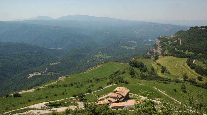
Cliffs of l’Avenc de Tavertet
Taking off over the Sau valley and the Osona plain, the Tavertet cliffs rise imposingly, offering a privileged viewpoint and, at the same time, preserving the landscapes of the plateaus. Not surprisingly, this sparsely populated territory offers a perfect balance between natural and cultural values.
ALL THE SPACES IN THE NETWORKGeology
This area is located in the Collsacabra mountain range that is part of the Transversal mountain range. It is located on the northeastern edge of the Ebro basin, near the Prelitoral mountain range, which here constitute the last foothills of the Montseny massif. This basin was filled with sediment during the Tertiary period, at the same time as Alpine orogenesis was raising the Pyrenees to the north and the Prelitoral mountain range to the south and southeast.
Tertiary materials (Eocene) are arranged above Paleozoic materials through erosive discord. The outlying rocks can be, at the bottom of the series, of continental origin (clays and red sandstones), or of marine origin, at the top (grey marshes, limestones and grey sandstones). It is very common to find abundant marine fossils in limestones, especially nummulites. The layers are sub-horizontal or slightly inclined. The differential erosion of hard and soft rocks (sandy and calcareous alternation and marl levels) has resulted in a large table skyline with the characteristic cliffs of Tavertet and Far. .
The quality of the landscape is of great beauty due to this great red and grey cliff, along with the contrast of the soft, worn skylines of the paleozoic rocks at the foot of the cliff. All the paths that run parallel to the cliffs can be considered a viewpoint above the Guilleries, the Sau reservoir and the cliff itself with its inputs and outflows, where some streams precipitate, forming waterfalls.
The action of water on carbonated rocks has led to an underground system of caves and chasms. Noteworthy is the Cave of the Serrat del Vent, which with its 4,273 metres in length and 215.5 metres in altitude, is the largest sandstone cave in the world.
This area is part of two Geological Areas of Interest declared by the Department of the Environment: geozones 215 and 216.
